Map-Based Collaboration for Process Focused Teams
Transforming location-based complexity into high-impact outcomes because where and when is at the heart of collaboration.
Mission
We solve critical challenges for teams managing spatially distributed operations.
Our mission is to empower organizations with real-time insights, streamlined workflows, and defensible data so they can move from complexity to clarity.
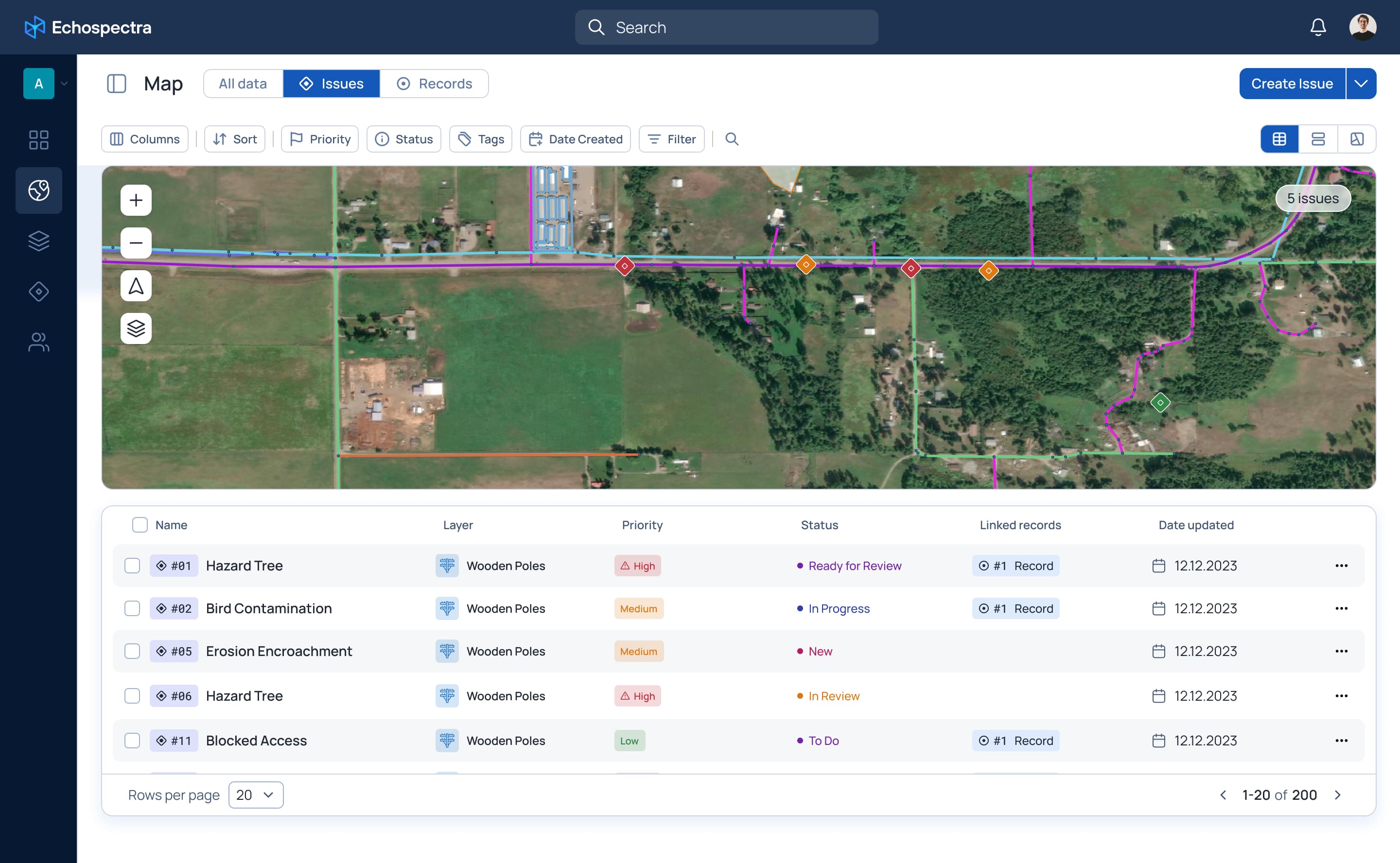
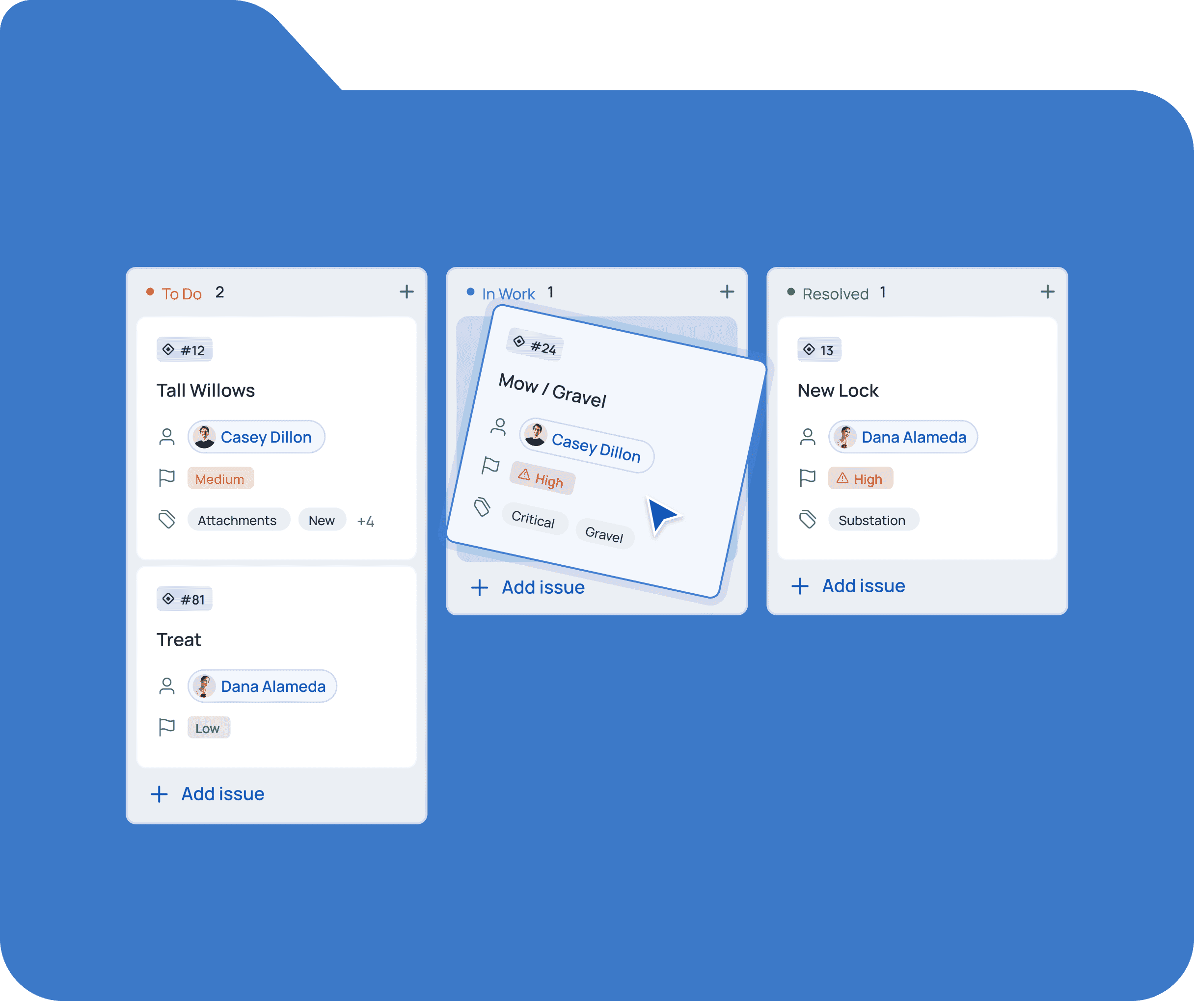
Smart Workflow
The Power of Place & Process
Smart Workflow
The Power of Place & Process
Smart Workflow
The Power of Place & Process
Smart Workflow
The Power of Place & Process
Data without process is noise
Our structured approach ensures consistency, accountability, and efficiency.
Decisions need context
We unify maps, workflows, and analytics so teams can see the bigger picture
Collaboration should be seamless
Echospectra keeps field teams, managers, and decision-makers in sync—no silos, no delays.
Data without process is noise
Our structured approach ensures consistency, accountability, and efficiency.

Decisions need context
We unify maps, workflows, and analytics so teams can see the bigger picture
Collaboration should be seamless
Echospectra keeps field teams, managers, and decision-makers in sync—no silos, no delays.
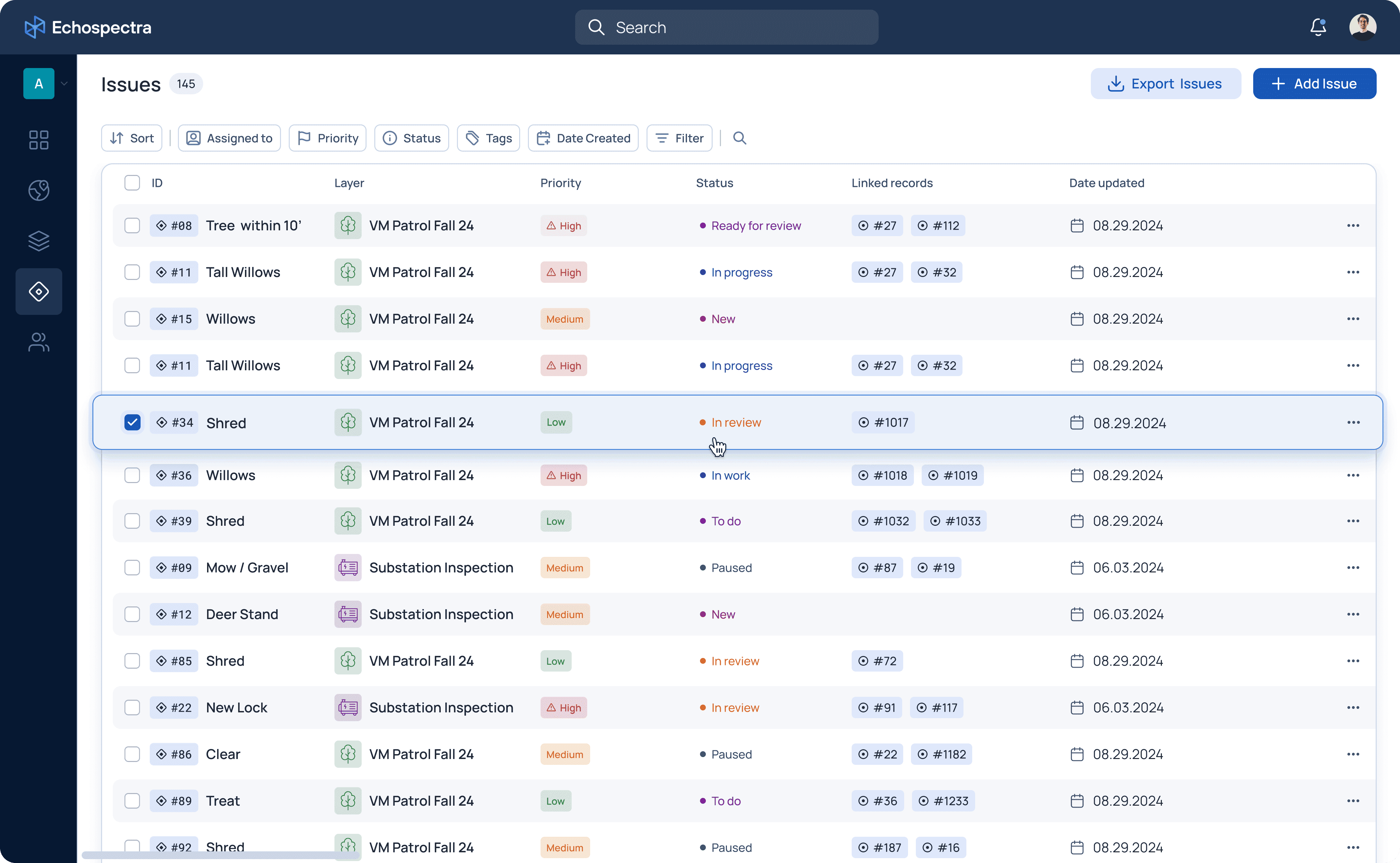
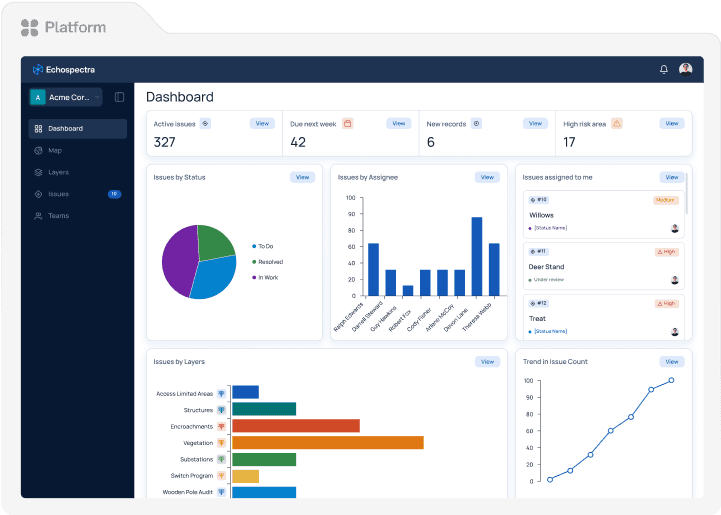
Software
Platform at a Glance
Software
Platform at a Glance
Software
Platform at a Glance
Software
Platform at a Glance
Real-Time Insights
Detect emerging risks or opportunities with instant map updates.
Real-Time Insights
Detect emerging risks or opportunities with instant map updates.
Real-Time Insights
Detect emerging risks or opportunities with instant map updates.
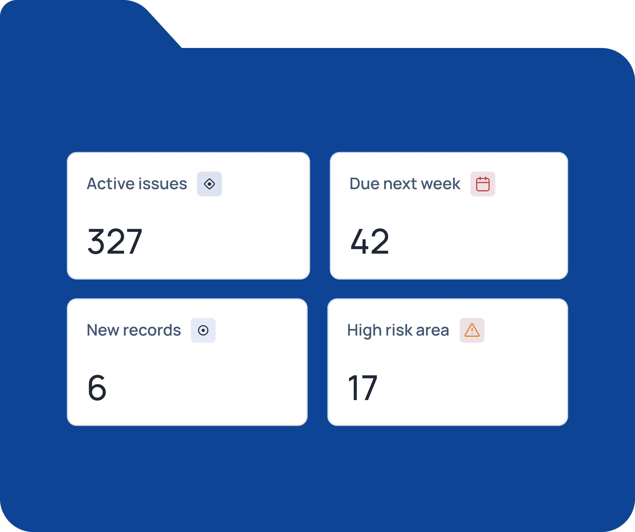
Efficiency Gains
Cut manual reporting time by up to 80% through automated data collection.
Efficiency Gains
Cut manual reporting time by up to 80% through automated data collection.
Efficiency Gains
Cut manual reporting time by up to 80% through automated data collection.

Transparent Activity History
Every interaction is logged and verifiable for governance and compliance.
Transparent Activity History
Every interaction is logged and verifiable for governance and compliance.
Transparent Activity History
Every interaction is logged and verifiable for governance and compliance.
Flexible Integrations
Connect seamlessly with ESRI systems or publish ESRI feature services into Echospectra.
Flexible Integrations
Connect seamlessly with ESRI systems or publish ESRI feature services into Echospectra.
Flexible Integrations
Connect seamlessly with ESRI systems or publish ESRI feature services into Echospectra.
Flexible Integrations
Connect seamlessly with ESRI systems or publish ESRI feature services into Echospectra.
Real-Time Insights
Detect emerging risks or opportunities with instant map updates.
Efficiency Gains
Cut manual reporting time by up to 80% through automated data collection.
Transparent Activity History
Every interaction is logged and verifiable for governance and compliance.
Flexible Integrations
Connect seamlessly with ESRI systems or publish ESRI feature services into Echospectra.
Solutions
How We Help You Work Smarter
Solutions
How We Help You Work Smarter
Solutions
How We Help You Work Smarter
Solutions
How We Help You Work Smarter
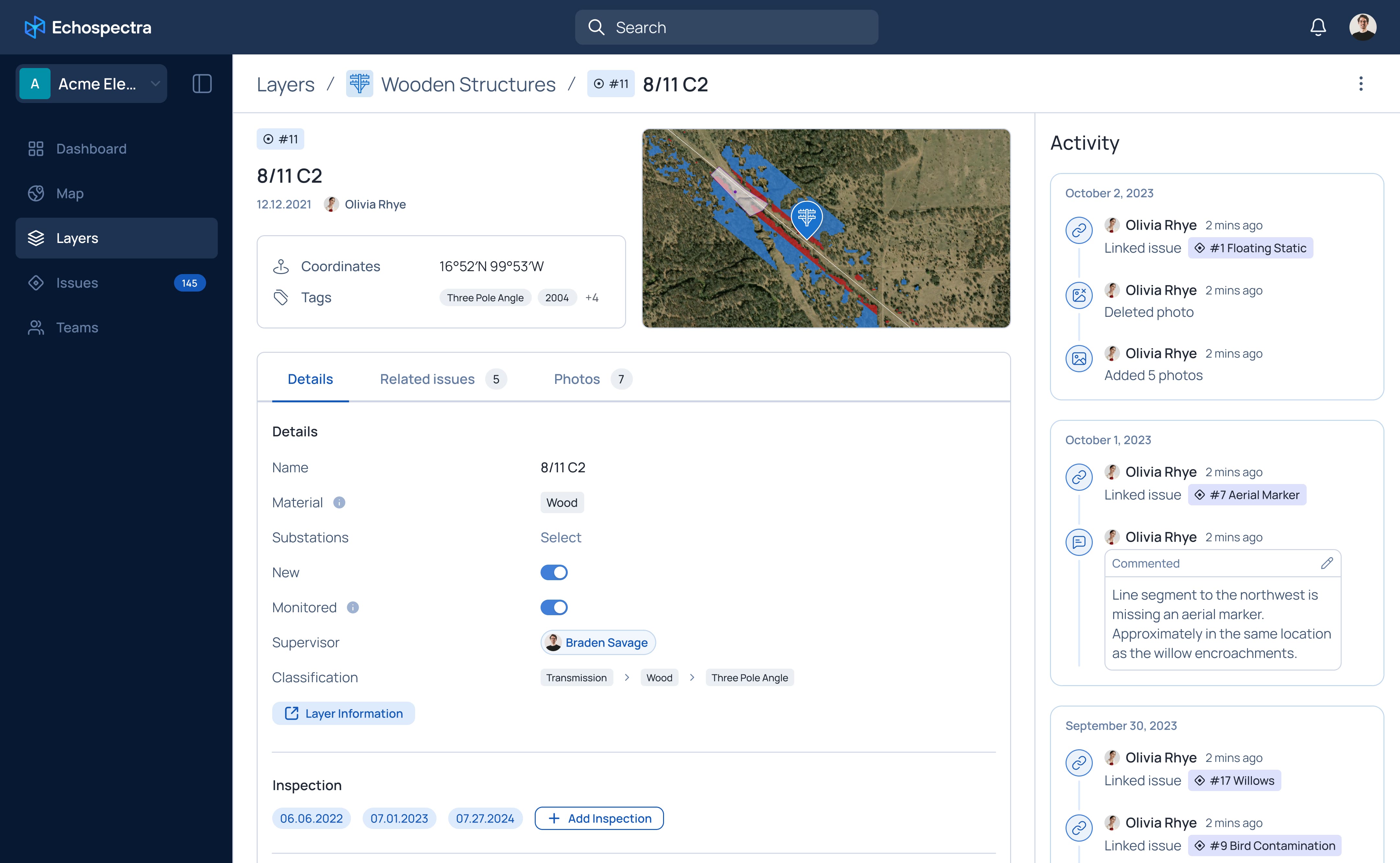
1. Your Single Source of Truth
Automatic Audit History
Enable automatic logging for every interaction to support reliable compliance and oversight.
Consistent Data Input
Standardized processes ensure high-quality, actionable information across teams.
1. Your Single Source of Truth
Automatic Audit History
Enable automatic logging for every interaction to support reliable compliance and oversight.
Consistent Data Input
Standardized processes ensure high-quality, actionable information across teams.
1. Your Single Source of Truth
Automatic Audit History
Enable automatic logging for every interaction to support reliable compliance and oversight.
Consistent Data Input
Standardized processes ensure high-quality, actionable information across teams.
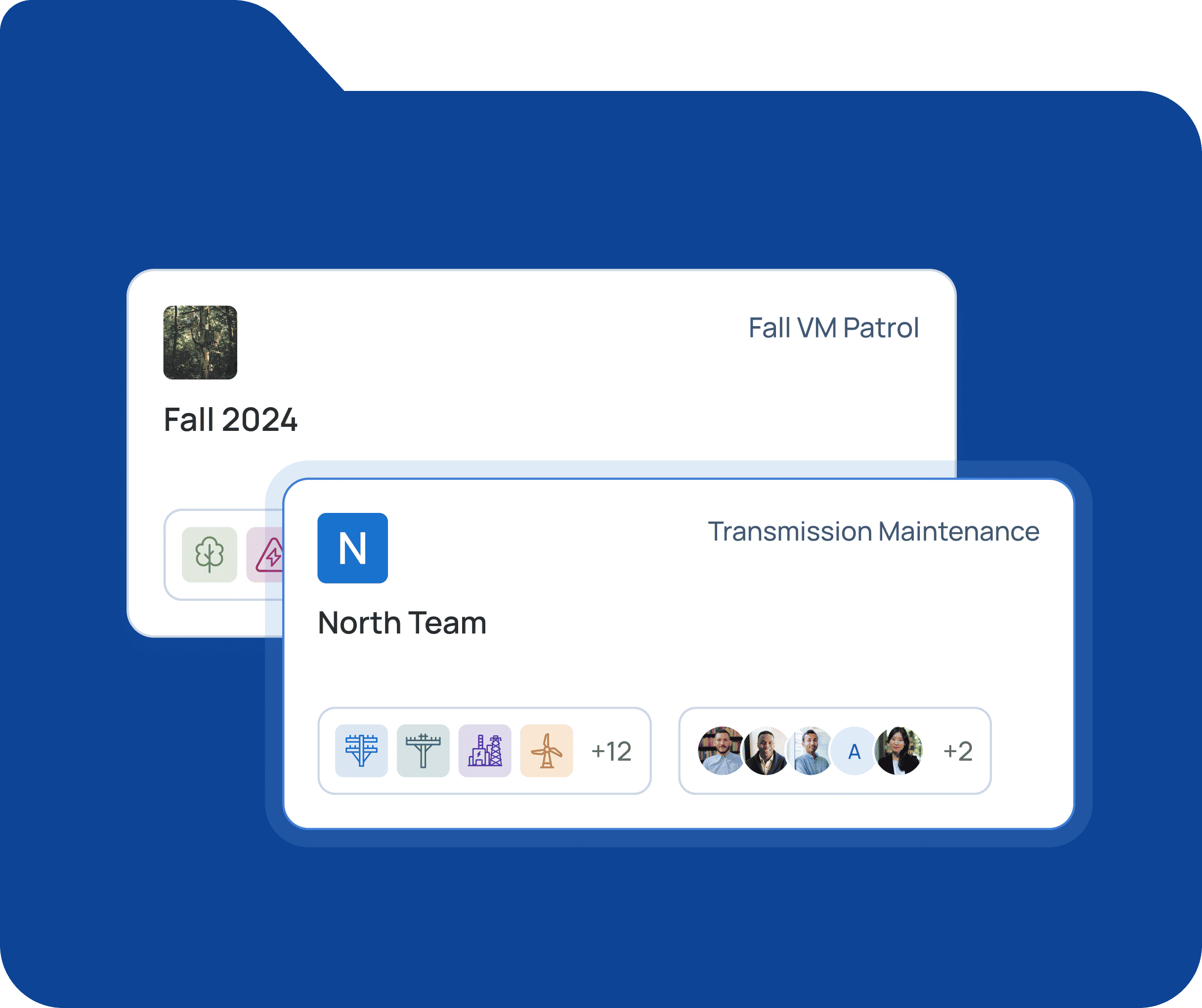
2. Stay in Sync, in Real Time
Live Collaboration
Keep field crews, managers, and stakeholders aligned with instant updates.
Instant Analytics
Rapidly identify issues and eliminate reporting delays.
2. Stay in Sync, in Real Time
Live Collaboration
Keep field crews, managers, and stakeholders aligned with instant updates.
Instant Analytics
Rapidly identify issues and eliminate reporting delays.
2. Stay in Sync, in Real Time
Live Collaboration
Keep field crews, managers, and stakeholders aligned with instant updates.
Instant Analytics
Rapidly identify issues and eliminate reporting delays.
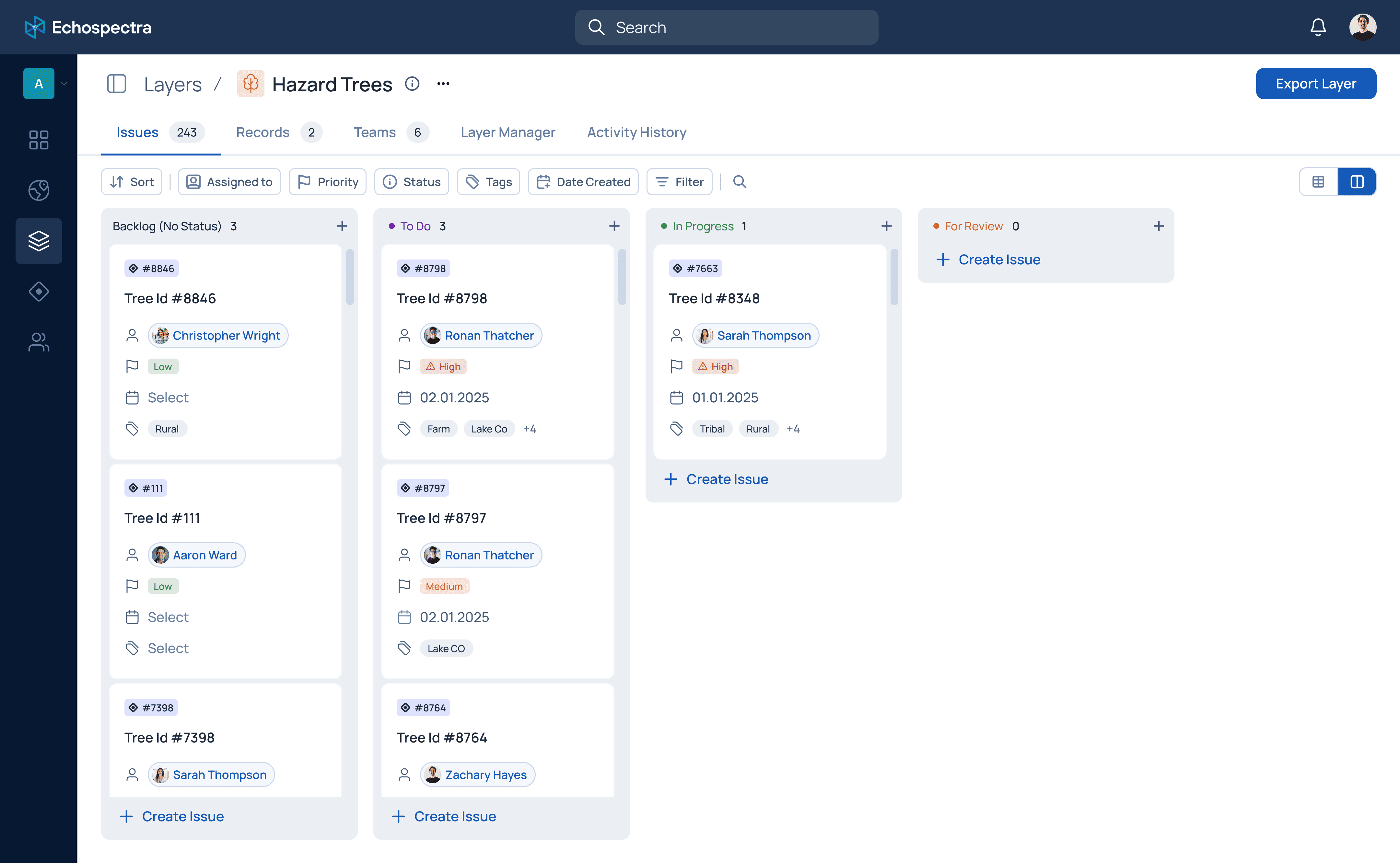
3. Uncover Hidden Risks
Map-Driven Insight
Visualize tasks geographically to spot trends and dependencies spreadsheets can’t reveal.
Strategic Prioritization
Identify compounding risks that require immediate attention.
3. Uncover Hidden Risks
Map-Driven Insight
Visualize tasks geographically to spot trends and dependencies spreadsheets can’t reveal.
Strategic Prioritization
Identify compounding risks that require immediate attention.
3. Uncover Hidden Risks
Map-Driven Insight
Visualize tasks geographically to spot trends and dependencies spreadsheets can’t reveal.
Strategic Prioritization
Identify compounding risks that require immediate attention.
4. Work Faster, Achieve More
Efficient Workflows
Streamlined data collection saves time and eliminates busywork.
80% Reduction in Reporting
Standardized forms and integrated tools cut manual processes significantly.
4. Work Faster, Achieve More
Efficient Workflows
Streamlined data collection saves time and eliminates busywork.
80% Reduction in Reporting
Standardized forms and integrated tools cut manual processes significantly.
4. Work Faster, Achieve More
Efficient Workflows
Streamlined data collection saves time and eliminates busywork.
80% Reduction in Reporting
Standardized forms and integrated tools cut manual processes significantly.
5. Scale and Evolve with Ease
Enterprise-Grade Security
AICPA SOC 2 compliance so you can focus on growth
Flexible Integrations
Seamlessly integrate with ESRI to have collaboration workflows around existing data
5. Scale and Evolve with Ease
Enterprise-Grade Security
AICPA SOC 2 compliance so you can focus on growth
Flexible Integrations
Seamlessly integrate with ESRI to have collaboration workflows around existing data
5. Scale and Evolve with Ease
Enterprise-Grade Security
AICPA SOC 2 compliance so you can focus on growth
Flexible Integrations
Seamlessly integrate with ESRI to have collaboration workflows around existing data
1. Your Single Source of Truth
Automatic Audit History
Enable automatic logging for every interaction to support reliable compliance and oversight.
Consistent Data Input
Standardized processes ensure high-quality, actionable information across teams.
2. Stay in Sync, in Real Time
Live Collaboration
Keep field crews, managers, and stakeholders aligned with instant updates.
Instant Analytics
Rapidly identify issues and eliminate reporting delays.
3. Uncover Hidden Risks
Map-Driven Insight
Visualize tasks geographically to spot trends and dependencies spreadsheets can’t reveal.
Strategic Prioritization
Identify compounding risks that require immediate attention.
4. Work Faster, Achieve More
Efficient Workflows
Streamlined data collection saves time and eliminates busywork.
80% Reduction in Reporting
Standardized forms and integrated tools cut manual processes significantly.
5. Scale and Evolve with Ease
Enterprise-Grade Security
AICPA SOC 2 compliance so you can focus on growth
Flexible Integrations
Seamlessly integrate with ESRI to have collaboration workflows around existing data
Trusted by Enterprise
Why Organizations Choose Echospectra


Solutions
Expert Services
Advanced Solutions Built on Our Core Platform
We leverage our capabilities in data science, machine learning, with domain expertise to solve specific problems
Industry-Specific Solutions
We solve critical challenges for industries where location, risk, and operational efficiency matter most.

Utilities & Infrastructure
Mitigate risk, enhance safety, and streamline operations.
Fire Risk & Vegetation Management – Hazard tree detection and encroachment monitoring using satellite imagery and AI.
Regulatory Compliance Automation – Standardized reporting and automated workflows for inspections, operations, and risk assessments.
OSINT Monitoring – Real-time tracking of weather, social media, and open-source data for hazard signals

Forestry & Environmental
Leverage spatial intelligence for sustainable land management.
Wildfire Management & Structural Defense – Optimize suppression strategies to protect critical assets in the Wildland-Urban Interface (WUI).
Environmental Compliance – Audit reforestation, carbon offsets, and habitat restoration, ensuring regulatory compliance and grant funding eligibility.
Landcover & Fuel Analysis – Monitor vegetation and model ecological impacts—supporting Community Wildfire Protection Plans (CWPPs), risk assessments, and operational planning.

Legal & Forensic
Turn complex data into compelling, defensible evidence.
Forensic Cartography – Integrate social media, cell phone data, satellite imagery, and public records to build clear, map-based narratives.
Evidence Compilation & Analysis – Combine information sources to uncover critical patterns and trends.
Expert Witness Support – Leverage technology to analyze large datasets and present spatially complex cases with confidence.

Insurance & Risk Intelligence
Improve underwriting, claims processing, and risk forecasting.
Dynamic Risk Scoring – Combine climate data, vegetation analysis, and OSINT for in-depth risk profiling.
Faster Claims & Post-Event Analysis – Forensic mapping to expedite damage assessment and liability evaluation.
Compliance Verification – Validate vegetation management and inspection efforts to reduce risk exposure.

Explore
See Echospectra in Action
Ready to Simplify Your Spatial Data Challenges?
Our team is here to show you how Echospectra transforms real-world operations for field, legal, and executive teams.
About Echospectra
Who We Are
About Echospectra
Who We Are
About Echospectra
Who We Are
About Echospectra
Who We Are
Echospectra is built by experts in spatial intelligence, communication, decision support, cloud architecture, and ML pipelines. We help organizations tackle complex, location-based challenges with confidence and clarity.
Our Promise
Deep technical knowledge for enterprise-scale challenges
Transparent, defensible data processes
Ongoing innovation in spatial analytics and collaboration
Frequently Asked Questions
How frequently can you monitor corridors from space?
What is the smallest change you can detect?
How do you assess fire risk?
Can this help me get fire insurance coverage?
Will this reduce our insurance premiums?
Does this require IT infrastructure and management?
Do I need a data science team to use this product?
What does Echospectra mean!?
Contact Us
Risk Intelligence and
Map-based Collaboration
Services
Utilities & Infrastructure
Legal & Forensic
Insurance & Risk Intelligence
© 2025 Ax0n Intelligence Company. All rights reserved.